MethaneSAT: A New Era of Transparency for Methane Measurement
MethaneSAT: A New Era of Transparency for Methane Measurement
MethaneSAT will fill critical gaps in the capabilities of existing methane data satellites and be a powerful tool to accelerate climate action.
Fast, Accurate Global Methane Data
A new generation of satellites is paving the way for vast improvements in methane emission detection and quantification on a global scale, ushering in a new level of transparency into methane emissions through regular, frequent data accessible to companies, regulators, investors, and – for some satellites – the public.
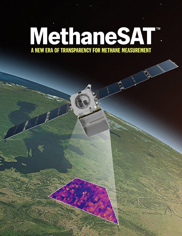
MethaneSAT, a satellite mission and wholly-owned subsidiary of Environmental Defense Fund, will measure methane pollution from the oil and gas sector globally, and make that information easily accessible and free for the public. Once in orbit, it will provide regular monitoring of methane emissions in regions accounting for more than 80% of global oil and gas production, quantifying methane emission rates and identifying where those emissions are coming from and how they are changing over time.
MethaneSAT is designed to catalyze real-world methane reductions through unprecedented transparency. Operators around the world will be able to find and fix problems faster, and stakeholders will be able to evaluate performance against methane goals, commitments, and legal obligations.
Report Highlights
- Demand for actionable, reliable data on methane emissions is growing among buyers and sellers of oil and natural gas, regulators, the financial community, and the public. Cutting oil and gas methane emissions is the single fastest, most impactful opportunity today to slow the rate of warming over the next few decades. This focus on methane underscores an urgent need for high-resolution data to quantify oil and gas methane emissions and enable efforts to quickly find and fix leaks.
- An emerging methane monitoring satellite ecosystem will enhance global transparency and accountability. Satellites can be used to determine how methane emissions are changing over time and how they compare across companies and countries. Some satellites have global coverage but can’t detect emissions from the many smaller sources responsible for a large proportion of total emissions. Others can attribute emissions on a facility level but can’t see beyond small areas. Together, they paint a fuller, more accurate picture than ever before.
- MethaneSAT will be a key part of this ecosystem and complement the capabilities of existing satellite technology. It will have a wide field of view along with a very high level of precision and a native pixel resolution of 100m x 400m to identify and measure even small amounts of excess methane. The goal of the mission is to quantify methane emissions from the majority of global oil and gas production regions, providing the data required to catalyze significant emissions reductions.
Key Takeaways
Photo credit: Nick Simonite
- For the O&G industry: Satellite emissions data can be used by oil and gas companies to make operations more efficient, monitor regulatory compliance, and ensure competitiveness and access to markets that increasingly look for lower emission-intensity hydrocarbons. Companies that integrate MethaneSAT data with their own emissions monitoring can achieve a greater degree of operational visibility, while those with significant gaps in emissions monitoring can use the data to guide planning.
- For the financial sector: Investors and other financial sector actors are increasingly concerned with financial, regulatory, reputational, and other risks associated with oil and gas company methane emissions, as part of a broader picture of operational competitiveness and energy transition risk. Using satellite data, such as from MethaneSAT, investors can judge a company’s competitiveness in methane management relative to peers and see how a company’s methane emissions change over time.
- For gas buyers: Many gas buyers are increasingly concerned about unnecessary and wasteful emissions in the value chain of the gas they’re importing. To support company and country-level climate goals, buyers might incorporate emissions and methane data from satellites in gas procurement contracts. Satellite data can help buyers screen for high-performing supply regions, compare gas suppliers, and assess individual sources in their portfolio.
- For regulators: Federal and international institutions, such as the US Environmental Protection Agency (EPA) and the European Union, are creating or enhancing rules regarding methane pollution. MethaneSAT and other emerging monitoring technologies will be crucial for filling a big data gap and assessing how effective regulations are once adopted.
Additional Resources
Read & Share
MethaneSAT will fill critical gaps in the capabilities of existing methane satellites and be a powerful tool to accelerate climate action.