Tibetan Permafrost, Urban Forests, Lava Paths, and Rural Marketplaces; Accelerating Our Understanding of the Planet Through the Education and Research Program
Through Planet’s Education and Research Program, researchers across the world are finding new ways of leveraging Planet’s satellite data to better understand how our societies and the world’s natural systems are intimately intertwined at every scale – from revealing the impacts of climate change on thawing permafrost to modeling how war impacts rural produce and marketplaces. With our datasets, these researchers are able to make novel discoveries and accelerate humanity towards greater understanding of our complex world.
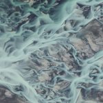
Thawing Permafrost
As the climate continues to warm, researchers urgently need means of monitoring permafrost degradation and its consequences in cold regions. One such region is the Qinghai-Tibet Engineering Corridor containing a major highway and a railroad across the Tibetan Plateau, where the permafrost is shallow, and therefore, vulnerable to degradation.
This melting permafrost can be seen as thaw slumps, areas of ice slope failures that subsequently retreat and expand which can cause the release of greenhouse gasses that were previously trapped in the frozen ground and damage to the surrounding infrastructure and ecosystems. However, conducting research on these slumps has been challenging in these high mountainous areas, and scientists are now turning towards Planet to gain remotely sensed data of these regions.
“Our recent study utilized PlanetScope imagery and deep learning for the generation of the very first comprehensive map of thaw slumps along the engineering corridor of the Tibetan Plateau,” said Dr. Lin Liu at the Chinese University of Hong Kong.
With the help of PlanetScope data, the study observed 875 thaw slumps with 38 of them located near roads or railways. The research team used these comprehensive datasets in combination with artificial intelligence to create a benchmark dataset for analyses of these fast changing slumps, and to assess the impact this may have on the critical road and railway infrastructure system. This framework looks to help stakeholders mitigate potential hazards in the region.
“We chose PlanetScope images not only because of their fine resolution but also their complete coverage and high quality. Those advantages provide fundamental support for small thaw slumps identification by visual inspections and deep learning networks in our framework,” said the Chinese University of Hong Kong research team.
Mapping Urban Forests
Urban expansion in Chattanooga, Tennessee, has been rapidly occurring since 1987. With this continual expansion also comes the fragmentation of local temperate forests, degrading habitat connectivity and decreasing forested areas which are culturally, ecological, and recreationally significant in the southeastern United States. However, in collaboration with the city of Chattanooga and the City Forester, University of Tennessee at Chattanooga master’s student, Will Stuart, is conducting research to map out the urban extent of the city’s forest canopy.
“Determining the extent urban forest canopy across a rapidly growing city could help direct sustainable development efforts towards areas urbanizing at an above-average rate, especially if the city’s administration is open minded to the principles of sustainable development,” explained Stuart.
Employing SkySat satellites, the research team obtained high-resolution imagery of the city in a rapid period of time as compared with traditional field sampling. Their research enabled them to conduct a spatiotemporal analysis of the modern urban forest extent and compare this to data over a 37 year period. Their findings indicated that impervious surfaces in the city have increased over the 37 years by 134% and the temperate forest area decreased by 43%.
“Thanks to the fine spatial resolution of [SkySat] imagery, a technique known as object-based classification can be successfully employed, wherein a selected machine learning algorithm (we used support vector machine) classifies real world objects within an image rather than classifying the individual pixels themselves,” said Stuart. “The fine spatial resolution of the multispectral imagery obtained by the SkySat constellation facilitates the successful classification of trees planted in urban landscapes with very small canopies that might otherwise be lumped into an adjacent developed class,” he further explained.
Preliminary research presented at ESRI User Conference 2022:

Simulating Lava Flow Paths
Satellite technology is being increasingly used to monitor volcanic activity, especially those found in remote areas. As lava flows can have devastating impacts on lives and regional economies, understanding the potential hazards of a volcano eruption is a priority for researchers. With satellite imagery, scientists are looking to both observe the changing intensity of an active eruption as well as work on the eventual forecasting of areas that may be vulnerable to future eruptions.
Researchers at the Istituto Nazionale di Geofisica e Vulcanologia, Sezione di Catania, Osservatorio Etneo in Italy are using a variety of remote sensing sources, including Planet data, to evaluate the 2011 Nabro volcano eruption in Eritrea. This eruption’s long lava flows had significant impacts on the inhabitants along the Eritrea-Ethiopia border.
“[Our research institute] worked with PlanetScope data to update the topographic changes at active volcanoes and quantify and measure the extent and thickness of volcanic deposits,” said Dr. Gaetana Ganci. “Planetscope data is also used to map vents and ephemeral vents during eruptions and to discover the presence of lava tubes,” he continued.
From these observations, the researchers were able to generate lava flow simulations to help understand the advance rate and flow extent of the lava flow, and observe the volcano’s eruption activity despite its remote nature. This research further demonstrated a step forward for volcano monitoring and hazard mitigation even in regions without ground-based volcano sensor networks.
“[Our paper] uses PlanetScope images to compute a post-eruptive digital surface model that allowed us to estimate the volume of lava erupted during the 2011 Nabro eruption,” said Dr. Ganci. “Quantifying the erupted volumes gives insights into emplacement processes and may aid computer simulations of lava flow paths for hazard assessment studies, providing both input data for predictive lava flow modeling, and tools for iterative validation or refining of parameters.”
The full study can be found in Remote Sensing of Environment.
Modeling Rural Marketplaces
In areas challenged by conflict and poverty, shifts in markets can be particularly challenging for rural communities. Agriculture and marketplace trade are vital to the livelihoods of small communities, but to build policies to support these economies, more information on the impacts of disruptions like lockdowns and violent conflict are needed.
Stockholm University’s Dr. Tillman Von Carnap-Bornheim used Planet satellite data to monitor this market activity in Kenya and Ethiopia, adding temporal and geographical details to existing research in this field. The study noted that Planet’s remotely sensed data offers a solution to monitoring such markets when ground analysis is infeasible, such as during times of war and violence.
“PlanetScope’s high frequency and resolution allow up-to-daily insights into what happens at rural marketplaces which are key locations for farmers to sell their crops and buy the products they need. I’m focussing on East Africa, particularly on how the war in Ethiopia affects activity in the markets there,” said Dr. Carnap-Bornheim.
By monitoring crowd activity and marketplace village infrastructure via satellites, the study was able to identify both the locations and attendance of communities at markets in addition to the timing of market days. This work was mapped against rainfall shocks to observe the impacts of rain on agricultural yields and therefore market activity, drawing parallels between all three economic factors. The research further revealed that market activity decreased during COVID-19 lockdowns and then again in regions nearby to the ongoing war in Tigray when violence occured.
“Researchers and policymakers rarely have access to high-frequency data on economic activity in low-income countries. That information would, however, be helpful to understand what policies work to reduce poverty, or to target humanitarian assistance in times of crises,” explained Dr. Carnap-Bornheim.
The full study can be found in SSRN.
Throughout the year, researchers and scientists are leveraging Planet data to better understand the complexities of the world we live in. We are proud to be supporting such vital work and look forward to showcasing more researchers soon. If you are using Planet data in your research and are interested in being featured in a future post, please email education@planet.com.
Learn more about how Planet’s Education and Research Program could help with your research here. Be sure to check out our Publications page to see published academic articles using Planet data, and don’t forget to follow us on Twitter to see the latest papers highlighted on #ScienceWednesday.


)