Rapid Response Research: The Chamoli Landslide
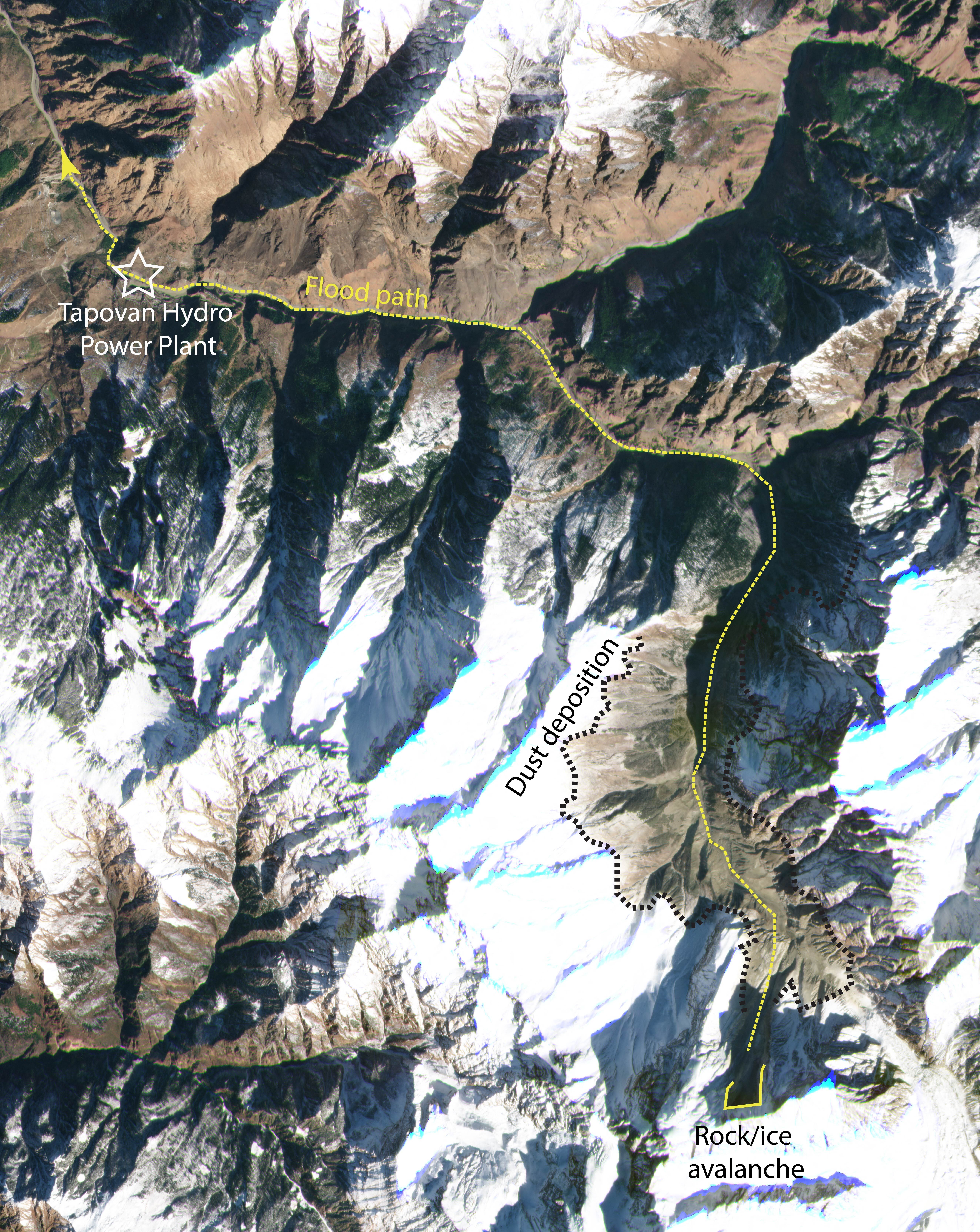
In a paper released last week in Science, researchers shared how they used Planet satellite data, combined with eye witness accounts, video on the ground, and other remote sensing datasets, to determine the cause of the massive debris flow that cascaded through valleys in Chamoli, Uttarakhand, India on February 7, 2021. The event killed dozens, with over 150 more missing. Two hydroelectric power stations experienced over $223 million in damage as the landslide made its way downslope, scouring rock and flattening forests. Planet’s satellites captured imagery that revealed critical information about what triggered this devastating event.
Based on seismic measurements on the ground, the landslide began at 4:51 UTC, traveling down the valley at nearly 60 meters (~200 feet) per second. Initial news reports stated that a glacier outburst flood triggered by a collapsing glacier was to blame. However, an international team of landslide experts led by Dr. Dan Shugar at the University of Calgary was able to quickly prove otherwise using PlanetScope imagery. Accessing imagery through Planet’s Education and Research Program, the team downloaded and analyzed imagery within hours of the landslide occurring—making news the very same day.
Planet’s Dove satellites passively image Earth’s entire landmass on a near-daily basis and were therefore able to capture imagery of disaster areas without the need for tasking. A Dove satellite passed over Chamoli at 5:01 UTC, a mere 10 minutes after the landslide began. Then, 27 minutes later, another Planet satellite imaged the same area, capturing the dynamics of the landslide in motion. Shugar’s team coordinated with Planet to rapidly acquire high-resolution SkySat imagery of the affected areas within hours. By analyzing these images, combined with eye witness accounts and video on the ground and other remote sensing datasets, Shugar and team were able to determine that the cause of the landslide was actually a massive rockfall at a location called Ronti Peak—one of the largest rockfalls ever recorded, collapsing from a height of about 3400 meters. Glacial meltwater, heavy rainfall in the preceding days, and water released from the hydroelectric power stations may have all contributed to the unusually high speed and mobility of the landslide as it progressed through the valleys.
“Although we cannot attribute this individual disaster specifically to climate change, the possibly increasing frequency of high-mountain slope instabilities can likely be related to observed atmospheric warming and corresponding long-term changes in cryospheric conditions (glaciers, permafrost),” Shugar and team note in their paper.
The pace at which this research was conducted was striking: four months from the date the landslide occurred to the date the paper was published. A team of over 50 scientists across fourteen countries mobilized to make this happen. “It was a pretty amazing experience to work with the very best in the field, and from all around the world,” Shugar says. “At nearly every hour of the day for a month, someone was working on some aspect.”
Early warning systems, combined with education on risks and actions to take in the event of an emergency, could help to save lives in landslide-prone areas like the Himalayas. “Videos of the event, including ones broadcast on social media in real time, showed that the people directly at risk had little to no warning,” Shugar and his team said. However, analyzing older satellite imagery, they found visible evidence of the slope that eventually failed and triggered the landslide had been moving since at least 2016—an early warning sign of the devastation to come. Monitoring for the signs of slope instability with satellite imagery can play a key role in taking preventative measures and deploying warnings to those in the potential path of danger, helping to save lives.
Learn more about how Planet’s Education and Research program could help with your research here.


)