Planet Data Helps Advance the Promise of Digital Agriculture and Enables Novel Water Dynamics Research
Ensuring food security and protecting aquatic ecosystems are essential for a sustainable future on our Earth. With Planet’s high spatial and temporal resolution satellite imagery, scientists are conducting novel research to sustainably increase agricultural productivity and monitor the dynamics of coastal water flows. With near-daily PlanetScope imagery, analysts can evaluate crop lifecycles to gain time-sensitive insights for nutrient inputs and irrigation systems, and with our SkySat sub-daily imaging capabilities, researchers can monitor the physical dynamics of natural water systems on an hourly basis.
Such research is currently being conducted by scientists from King Abdullah University of Science and Technology’s (KAUST) Hydrology, Agriculture and Land Observation (HALO) group, which explores innovative solutions to address sustainability challenges in Saudi Arabia and elsewhere in the world. Using satellite data, unmanned aerial vehicles (UAVs) and other novel technologies, HALO monitors and models Earth processes, seeking to better predict key environmental systems.
“Resilience in water and food supplies represent two major elements of the Kingdom’s efforts towards a secure and sustainable future,” said Matthew McCabe, Professor of Remote Sensing and Water Security, and Director of the KAUST Climate and Livability Initiative. “Improving our description and understanding of the water-food nexus is a key objective [as we aim] to provide real-time and relevant information streams that aid in the decision support of these systems.”
The HALO group has used a variety of methods to analyze environmental changes over time, model agricultural growth patterns, and evaluate irrigation sources, including Sentinel-2 data and UAV data. However, the group began looking for a way to increase the accuracy of their models by using data with a daily cadence, which could be scaled to large areas. Planet’s high temporal and spatial resolution data offered a solution.
Leveraging our PlanetScope and Fusion data products, researchers from the HALO group have published innovative research on continuous daily monitoring of leaf area index (LAI), a unit of measurement revealing the amount of leaf material in a given crop field location. LAI can help determine stages in a crop lifecycle, and support the timely management of these crops. As a research test site, the paper evaluated maize fields in Nebraska, USA, and results demonstrated that by using data collected from Planet satellites, researchers could provide spatially explicit yield predictions broadly.
“We have deployed a new multi-satellite image fusion methodology that produces daily cloud-free and gap-filled Planet data in combination with a machine learning approach to predict LAI – an important plant biophysical variable,” shared Dr. Kasper Johansen, a Research Scientist leading several of these efforts. “The time-series of LAI maps can be related to specific phenological stages of the maize plants, which may drive treatment and irrigation scheduling and site-specific management intervention to increase crop production.”
With an ability to accurately and scientifically monitor these processes on a daily basis, researchers can support regional sustainability policy and management interventions that aim to facilitate food and water security initiatives. “Planet-derived LAI values correlated well with field-based validation measurements and several key phenological stages were identifiable from the LAI maps,” explained Johansen. “Due to the high spatial and temporal resolution of PlanetScope data, the imagery can advance the promise of precision agriculture, delivering the capacity to increase food production while using fewer inputs and reducing the environmental footprint of farming.”
The HALO group also works across departments at KAUST to advance their environmental systems research. Recently, the group collaborated with the Red Sea Research Center to publish a first-of-its-kind demonstration that monitors coastal water flows using dye tracing along the Saudi Arabian coast of the Red Sea. The groups leveraged Planet’s high resolution SkySat satellites to delineate dye plume extents, track plume movements, and measure dye concentration as an indicator of dispersion.
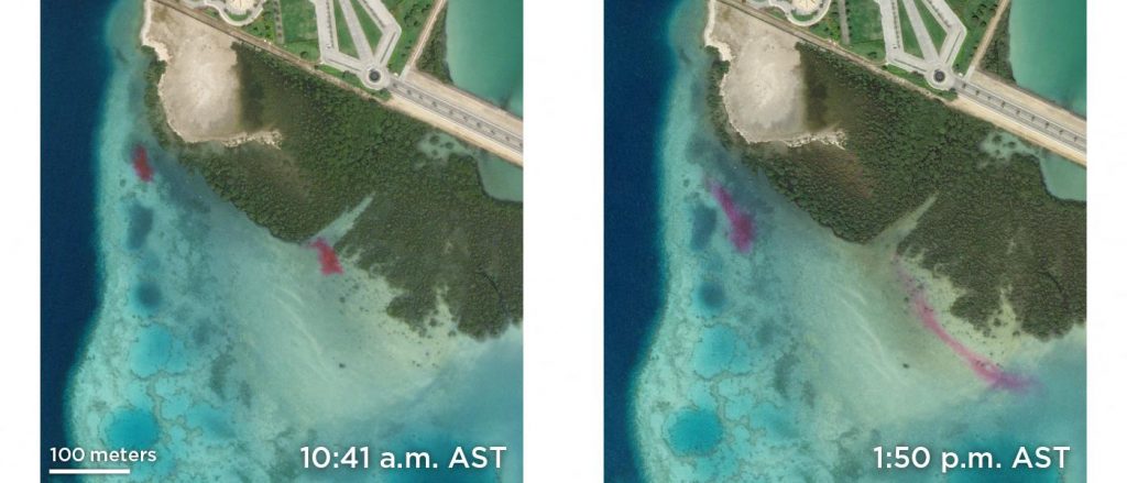
“Due to the high spatial and temporal resolution of SkySat data, the imagery is ideally suited for monitoring fine scale dynamic features and events,” said Johansen. He explained that for dye-tracing, field instrumentation is difficult to deploy and labor intensive to use, while UAVs prove useful, but have limitations when it comes to large-scale coastal dye-tracing. Meanwhile, their paper demonstrated that SkySat data offered a novel capability to monitor large extents of dye plumes with accuracy.
“We deployed high spatial resolution SkySat imagery collected about 3 hours apart to monitor the movement of two dye plumes using an object-based mapping approach for delineation and tracking,” explained Johansen. “We then predicted the dye concentration using a machine learning approach and coincident UAV data for model calibration to bridge the spatial and temporal disconnect between field and SkySat data.”
This study offers a demonstration of what can be achieved in the future for monitoring coastal dynamics. This work can also help reveal the movements of nutrients and pollutants in vital water resources. SkySat’s ability to offer sub-daily high spatial resolution data enables researchers to trace rapidly changing environmental systems that are important for sustainability efforts.
“Information on coastal water flows and their dynamics can facilitate management intervention and conservation activities of seagrass, mangrove and coral reef ecosystems and provide a better understanding of the movement and dispersion of nutrients, sediments and pollutants in coastal areas,” said Johansen.


)