The NICFI Satellite Data Program: Celebrating Three Years of Using Space to Help Reduce & Reverse Tropical Forest Loss
By Seamus Lombardo, Luisa Teixeira, Tara O’Shea
Every quarter, we publish a blog post that highlights some of the amazing work of the NICFI Satellite Data Program’s community of users. This October, we are pleased to not only continue this tradition, but also celebrate three years of this program and contract, a unique public-private partnership to leverage commercial Earth observation technologies to advance the public purpose of Norway’s International Climate & Forests Initiative.
To celebrate three years of the program to date, we decided to compile some of its impacts on the seven NICFI Strategic Areas. Take a look below to learn more about how commercial space technologies are helping advance these international initiatives for reducing and reversing tropical forest loss.
Strategic Area #1: Land Use Policies
Land use governance is critical to reducing deforestation, decoupling deforestation from commodities production, and meeting global climate and sustainable development goals. Reducing and reversing tropical forest loss goes hand in hand with governing for more sustainable land use. Through the NICFI Satellite Data Program, Planet Monthly Basemaps products have helped a number of developing and emerging country governments more sustainably manage their land use in order to meet their national development goals and international climate pledges.
Some examples include:
- Six Congo Basin Countries, through the Central African Forest Initiative, are using the NICFI Satellite Data Program Level 1 Basemaps to better understand drivers of deforestation and degradation – and thus improve policies for managing these drivers in their landscape planning.
- In Laos, the government has worked with GIZ to use the Program’s data to increase clarity of local land tenure, helping prevent outside interventions that drive deforestation rates.
- In Guatemala, the government is leveraging the Program’s data to complement its forest assessment. Through this assessment, they are able to reinforce the country’s National Forestry Incentives System.
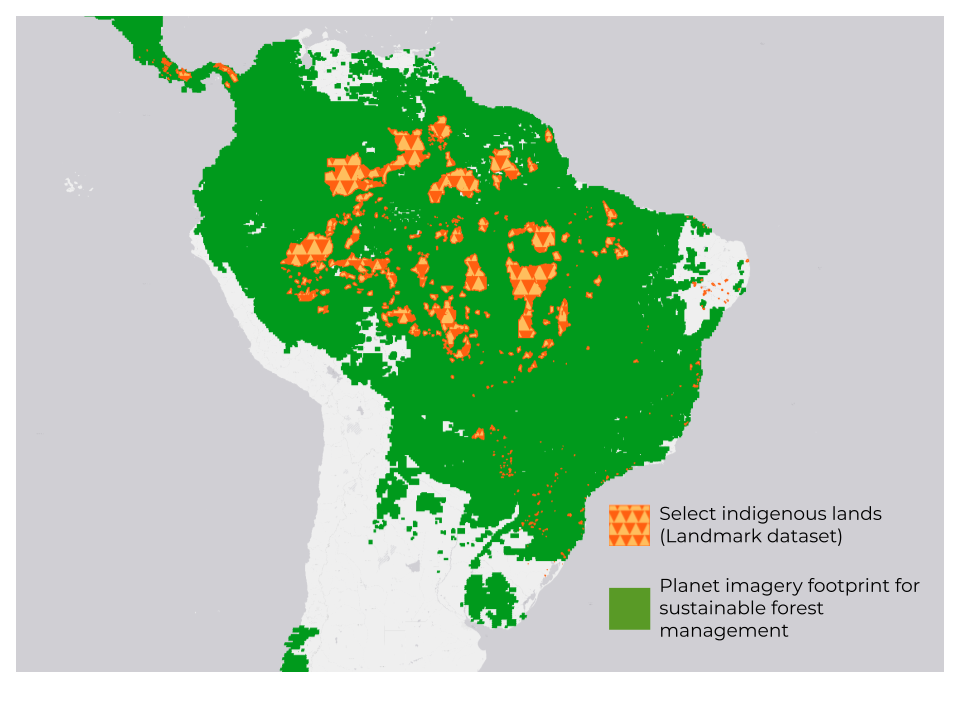
Strategic Area #2: Rights of Indigenous Peoples
There is growing scientific consensus that stewardship of forests by indigenous peoples averts deforestation. Yet these indigenous communities and their ancestral lands are under intense deforestation pressure and subject to a host of negative impacts of forest loss. NICFI Satellite Data Program Level 1 data has been used extensively by indigenous communities to support their efforts to prevent deforestation. The program, along with platform partners, continues to advance applications by these communities who are often socioeconomically vulnerable. Planet-NICFI survey data indicates dozens of users employing Planet data in contexts related to indigenous communities.
- The Rainforest Foundation US has facilitated training of 36 indigenous communities in the Amazon on the use of Planet-NICFI data to combat deforestation. The GEO Indigenous Alliance has also made use of NICFI Satellite Data Program Level 1 data in their efforts to build monitoring capacity in indigenous communities including through hackathons.
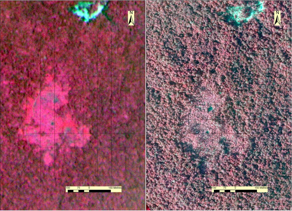
- The Program’s data has been used to provide evidence of illegal mining on the Yanomami indigenous lands in service of legal efforts to remove the illegal incursions.
- The NICFI Satellite Data Program Level 1 and Level 2 data is being used both by NGOs such as Fundación EcoCiencia and Amazon Conservation to support land monitoring for indigenous sovereignty.
Strategic Area #3: Carbon Markets and International Support Structures
The consistency, transparency, and rigor that high-resolution data provides is helping overcome previous roadblocks to the potential of REDD+ programs, policies, and other carbon markets. Level 1 Planet data is actively used by governments, NGOs, companies, and researchers as a crucial data source for monitoring, mapping, and change detection within REDD+ MRV; and the Program’s Level 2 Planet and SPOT data provide critical updates for reference (baseline) levels. These tools increasingly help facilitate REDD+ verification and performance based payments.
A few examples include:
- Successful REDD+ performance based payments to countries: Costa Rica produced land use maps using Planet data for its forest reference level, a requirement for results based payments. Costa Rica has received payments for 10 million tCO2eq.
- Increasing REDD+ capacity in Africa: NICFI-Planet data has been used for Cameroon and by Mozambique for MRV on REDD+ programs. Recent research also shows the benefits of Planet data for REDD+ initiatives in Tanzania and Ethiopia.
- 89% of Guyana’s forests, which sequester 8.9 billion tons CO2e (ESA CCI dataset), are imaged with Planet data to support sustainable forest management. Guyana is successfully issuing verified emission reductions and has signed significant purchase agreements on that carbon with Norway and with Hess Corporation.
Strategic Area #4: Transparency
Transparency is the basis for prevention and condemning forest crime. As in Planet’s motto “You can’t fix what you can’t see,” visibility into a region is crucial for effective action, and new technologies can help actors from the private sector, media, and NGOs with that.
A few examples include:
- A breakthrough study of clandestine airstrips in the Brazilian Amazon rainforest, conducted in a partnership between The New York Times, The Intercept, the Pulitzer Center, and Earthrise Media, found more than 1,000 illegal airstrips supporting mining areas within indigenous and protected lands, where any form of mining is against the law.
- AidEnvironment’s work tying native vegetation clearance and fire alerts to soy and cattle production in the Amazon and Cerrado biomes, which are made publicly available in their monthly Realtime Deforestation Monitoring Reports.
- Participation in trainings and workshops with partners and users to bring awareness to the power of Earth observation for transparency in forest business and communities:
- With explorer.land, a map-based platform that serves as a bridge between nature-based projects and funders, exploring how the NICFI Satellite Data Program Level 1 Basemaps bring increased Transparency in Practice.
- With Mongabay, a nonprofit conservation and environmental science news platform, environmental data journalism is helping demonstrate how tools like Global Forest Watch and Planet-NICFI data can be used to identify and communicate the changes occurring in forests across the tropics.
- With the GEO Indigenous Alliance, running a roundtable to bring together Indigenous Peoples and Local Communities to share and discuss on the power of Earth observation and geospatial data for climate action.
Strategic Area #5: Deforestation-Free Commodity Markets
Frequent, high-resolution Planet data helps promote the transparent and rigorous enforcement of sustainable supply chain initiatives through identification of illegal pastures, mining, logging, and expansion of agricultural land linked to deforestation and forest degradation. These capabilities can strengthen regulatory (e.g. EU’s Deforestation Regulation and Corporate Sustainability Reporting Directive) and voluntary (e.g. Science Based Targets for Nature and Science Based Targets Initiative, Forest, Land and Agriculture) efforts as they come into effect – and thereby stimulate sustainable business compliance operations – by 2024.
A few examples include:
- Identifying and mapping commodity supply chain assets: UK Ordnance Survey pilot is using NICFI Satellite Data Program Level 1 data to create a location register which provides a trusted location platform to conduct due diligence on commodity assets to identify, prevent, or mitigate risk through more effective monitoring and smart procurement contracts.
- Palm oil and pulp/paper supply chains: Multiple NGOs identified deforestation due to palm oil plantations using the Program’s data, as well as deforestation due to pulp and paper supply chains.
Strategic Area #6: Deforestation-Free Financial Markets
There are a growing number of compliance-based and voluntary ESG corporate reporting frameworks that seek to increase the accountability of investors and businesses’ impacts on nature, including tropical deforestation, through assessment, reporting, and disclosure. These efforts (ex: TNFD and SBTN) seek to channel capital into positive actions and embed nature-based targets in capital markets. These reporting efforts accompany commitments from financial institutions to address deforestation. Survey data indicates that the NICFI Satellite Data Program has advanced user interest, R&D, and applications in this space – with dozens of NICFI-Planet users from the finance and insurance sector. Arguably, the program is thereby helping stimulate sustainable business compliance operations as new regulatory disclosure requirements come into effect in 2024.
Some examples include:
- Quantifying financial impact of logging: Where the NICFI Satellite Data Program data has been evaluated by the International Finance Corporation for a project to quantify the financial impact (in terms of missed tax revenue) of logging on the Solomon Islands, an example of increasing use of satellite data in finance contexts.
- Developing sustainability indicators: NGIS is using Planet-NICFI data to help companies develop sustainability performance indicators.
Strategic Area #7: International Forest Crime
With its broad high-resolution coverage, including wall-to-wall coverage of remote forest areas, NICFI Satellite Data Program data can also help aid in the detection and prosecution of forest crimes. These capabilities are strengthening efforts by NGOs, like the United Nations Office on Drugs and Crime, and journalists to expose and identify forest crimes as well as support government enforcement agencies in seeking to mitigate forest crimes.


)