Planet and NGIS Enable Emergency Services Preparation Ahead of Australia’s Fire Season
We have globally seen a record breaking fire season in 2023, and from Canada to California, Planet data has been leveraged to monitor and prepare for these fires, helping protect civilians and conserve natural resources. Over the years, our data has also provided critical insights for managing and mitigating bushfires in Australia. This year, Australia is on high alert for a potentially dangerous bushfire summer, according to Reuters, as the El Niño weather system has reportedly produced more foliage than previous years which could provide additional fuel for fires when the dry season comes.
Our partner NGIS is helping the government of New South Wales (NSW) prepare for this high-risk season with Planet satellite data. Leveraging both our PlanetScope data and our SkySat imagery, NGIS and NSW are able to collect both medium-resolution near-daily insights on where vegetation growth has increased and high-resolution tasked imagery of fires in action.
Learn about how NGIS and NSW are preparing for this upcoming season in their cross-posted blog below:
# # #
PUBLISHED ARTICLE FROM NGIS || LINK
HOW FIRE AND EMERGENCY SERVICES ARE ACCESSING SATELLITE IMAGERY ACQUIRED AUSTRALIA-WIDE EVERYDAY, TO PREPARE FOR AND MITIGATE THE IMPACTS OF THE BUSHFIRE SEASON
“It’s the biggest risk we’ve faced since the 2019-20 fire season,” New South Wales Rural Fire Service Commissioner, Rob Rogers – Sky News, September 2023.
With the Bureau of Meteorology declaring in September that Australia was now in an El Niño climate pattern, Eastern parts of Australia are likely to experience an “increased risk” of bushfires due to forecasts of above-average temperatures, decreased rainfall, high fuel loads and changing weather patterns, according to the Australasian Fire Authorities Council (AFAC) outlook.
Record-breaking September temperatures have seen bushfires occurring in New South Wales, Queensland and Tasmania at the onset of the bushfire season, all but validating the risk forecasts and prompting calls from State Government officials and emergency management authorities to prepare for intensifying conditions.
The Black Summer fires in 2019/2020 are among the worst Australia has seen, costing Australian agriculture between $4 billion and $5 billion. NGIS responded to several disaster events with spatial analysis and earth observation solutions, enabling responding agencies to identify, monitor and analyse the events to improve coordination and decision-making. Today, visualising imagery of an affected area from a bird’s eye view allows for a comprehensive understanding of the scope and severity of disasters such as bushfires. This information can be used to make more informed decisions about evacuation routes, emergency response efforts, and potential damage assessments in real-time; however, daily monitoring of Australia’s entire landmass makes it possible for pre-, during and post-event temporal analysis.
Our imagery partner Planet, provides timely and analysis-ready satellite imagery, useful for bushfire planning and response. Founded in 2010 by three NASA scientists, Planet designs, builds, and operates the largest commercial Earth observation fleet of imaging satellites, capturing over 30TB of data daily. Planet currently operates two satellite constellations: Dove satellites, which provide a daily scan of all the Earth’s landmass at three-metre resolution, and SkySat tasking satellites, which capture tasked images at 50cm resolution of any location on Earth on-demand.
The advantage of these two constellations is that they offer imagery when needed almost anywhere in Australia. Together with NGIS’s geospatial solutions and Planet’s data, we make timely information from space visible, accessible, and actionable. With tools such as Planet’s Explorer search and discovery interface and Stories timelapse viewer, NGIS is assisting agencies in viewing imagery faster – before, after and during bushfire events. For more information on how NGIS can help your organisation with Planet imagery, click here. View bushfire events we’ve observed from Planet’s imagery below.
BUSHFIRE EVENTS
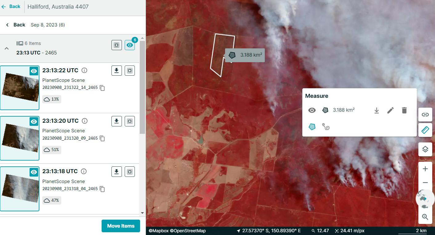
Emerald QLD Fire | September 2023
The fire season in Queensland has begun, prompting residents of rural towns like Emerald and Beerwah to consider returning to their homes cautiously after evacuating. Bushfires are unpredictable, and conditions can shift rapidly. Residents have received specific guidance to remain vigilant, particularly regarding potential hazards like burnt trees, embers on the ground, and fallen powerlines.The aftermath of a bushfire can bring about significant challenges, including power outages and disruptions to phone and internet connectivity. Moreover, the presence of smoke may linger several days following the fire’s containment.
View Planet story:
Mount Banks (Blue Mountains) NSW Fire | December 2019
In the Summer of 2019, prolonged and extremely high temperatures with significantly reduced rainfall, extraordinarily low humidity and periods of high winds produced fire conditions and behaviours not seen on such a vast scale before in the Blue Mountains. Over 80 per cent of the national park in the Blue Mountains was impacted, with over 122 million mammals, birds and reptiles impacted.
Our very own Brittany Baker (Dahl) was part of the effort to distribute mapped projections of fire spread during this time. Brittany recalls the sky full of smoke during the event, with air pollution lingering as fires spread around the Blue Mountains throughout the summer.
View Planet story:
Orroral Valley (Canberra) ACT Fire | January 2020
The Black Summer disaster continued into early 2020, with fires starting across ACT – including over 82,700 hectares of Namadgi National Park. Major fire events in this area, including the Orroral Valley Fire, impacted threatened ecological communities (alpine bogs), biodiversity (water quality for aquatic species, large gliders, threatened flora and fauna, fire-sensitive communities, hollow-bearing trees, aquatic and riparian habitat) and water quality (sediments and nutrients in water catchments) in the area.
The imagery from space before, during, and after the event provides insight into the fire’s behaviour and changes in vegetation. Post-burn scarring on the landscape can be seen, displaying a deep red hue in the imagery below.
View Planet story:


)