How AMAGGI Uses Planet Data to Take Sustainable Agriculture to the Next Level
You can also read this blog in Portuguese and in Spanish.
Sustainable production requires measures such as reducing the use of pesticides. Each decision about how to maximize sustainable production requires a level of insight that can be difficult to access. And technology can help solve this challenge, as shown by AMAGGI, a Brazilian agribusiness multinational.
With over 411,000 hectares of annually productive planted area, AMAGGI is committed to sustainable practices. They invest in precision agriculture to reduce impacts on the environment. And with that focus, they have a rich history of digital transformation and using cutting-edge technology.
Ricardo Moreira, Production Control Manager for AMAGGI’s Agro, explained during a recent webinar, “In agriculture, there are countless variables. To isolate one from the other, you really have to have a lot of data.”
So, in addition to data captured by field workers and from telemetry and other sensors measuring factors like humidity, temperature, and precipitation, the AMAGGI team decided they needed Planet geospatial technology to capture even more information.
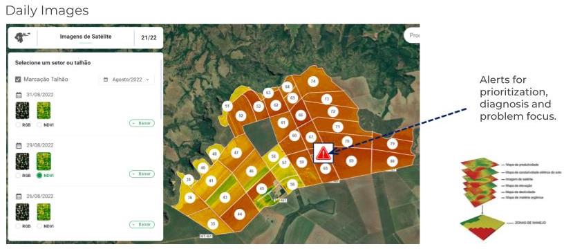
Satellite imagery provides the company with a practical solution to the problem of scale. “It is not humanly possible to monitor details of an entire 50,000 hectare farm on a daily basis, no matter how many people you assign to the task,” Moreira said.
The temporal resolution of Planet images allowed AMAGGI to use change detection analysis to locate problems faster. By generating an alert, the company could quickly understand the adversities of the crop, make informed decisions, and act faster.
This is particularly useful for annual crops like soya and cotton, which have 90 to 180-day cycles. If there are any anomalies and you don’t respond quickly, the impact on productivity can be devastating. “Monitoring has to be constant,” explained Moreira. “And it’s not only having a temporal analysis but also a speed between a current image and a previous image to see any variation, for better or for worse. The data behind that image is essential because that’s what generates an insight or an alert for you to look at a certain point in the field instead of monitoring 100% of your area.”
Leveraging over 8.7 million images from the Planet database dating back to 2017, AMAGGI was able to conduct trend analysis and take a preventative approach to various challenges it faces.
AMAGGI has also increased the value of each image by extracting NDVI data from it, which unlocked powerful insights for sustainability. “We generate NDVI maps to create agronomic recommendations to control cotton growth; that is, to apply growth regulators,” Moreira said.
With Planet imagery, AMAGGI has “a more dynamic and better view of the height of the cotton. We can make variable rate maps, which has led to savings in the use of pesticides.” That reduction in pesticide usage ultimately lessens the environmental impact and improves crop quality.
In short, Moreira said Planet imagery lets AMAGGI “generate knowledge for decision-making, through the entire agricultural process — from the time you are preparing the soil until the time you are harvesting.” Imagery is available through AMAGGI’s many platforms and on remote devices to field workers, agricultural technicians, and agronomists to help with decision-making throughout the organization.
All of this has led to Moreira’s conviction that AMAGGI made the right choice by investing in Planet imagery. On the question of ROI, Moreira said, “the gain is not only in the economy; the gain is also in the increase in productivity and in doing the right thing at the right time.”
Moreira is also convinced that AMAGGI’s collaboration with Planet points to more digitally-driven sustainability initiatives on the horizon.
“In the very near future, we will start automating things. And then Planet imagery will make an even bigger difference because, in addition to identifying a certain problem, it will give you a spatial notion of the routing of these machines. We will have visibility on the management platforms that is a little closer than having an older or outdated map. AMAGGI has always been at the forefront of things,” Moreira concluded. “If you want to be more productive and less harmful to the environment, technology is essential.”
Watch the webinar in Portuguese or Spanish to learn more about how AMAGGI’s collaboration with Planet has powered a more sustainable approach to agriculture.


)