Greece Sees Its Most Intense Wildfire Emissions For July On Record
The intense wildfires burning in Greece since 17 July have quickly become the worst recorded since at least 2003 for the month of July. Data from the Copernicus Atmosphere Monitoring Service’s (CAMS) Global Fire Assimilation System show that the wildfire emissions for Greece overall increased quickly on 17 July, with a Total Fire Radiative Power (red bars) very high compared to the average of the previous 20 years (grey bars).

The largest wildfires started by that date west of Athens and the island of Rhodes, forcing nearly 20,000 people to evacuate, in what’s considered the largest evacuation from a wildfire in the country, according to the Ministry of Climate Change and Civil Protection.
Large wildfires erupted also in Attica, near Athens, but there were smaller fires across the country, including Evia and Corfu, coinciding with a record-breaking heatwave in the Mediterranean.
As a result, the CAMS GFAS data show the highest wildfire carbon emissions in July recorded for Greece, by a very large margin, with over 1 megatonne of carbon emitted until 25 July.

“Unfortunately, it is not all that surprising, given the extreme conditions in the region. The observed intensity and estimated emissions show how unusual the scale of the fires have been for July relative to the last 20 years of data that we have from our Global Fire Assimilation System. Our data also shows that the previous highest years (in 2007 and 2021) occurred under heatwave conditions with more fires in August, and we will continue monitoring very closely fire emissions in Greece and around the Mediterranean until the end of the summer,” says Mark Parrington, CAMS Senior Scientist.
In terms of the area burnt, on 22 July the Greek fire season was on pair the highest figures on record, with more than 35,000 hectares burnt, according to the European Forest Fire Information System EFFIS. Areas of Spain, France, Italy, Greece, Turkey and Northern Africa are in “Very Extreme Danger” on the EFFIS’ Fire Danger Forecast.
The Copernicus programme Sentinel satellites have captured images showing the extent and intensity of the Greek wildfires. This Sentinel-2 satellite image shared by the EU Commission’s Directorate-General for Defence Industry and Space DEFIS communications team shows the large scar of the wildfire in Attica on 19 July.

The Rhodes fire smoke was even clearly visible in EUMETSAT’s new meteorological satellite MTGI1, initially not designed to capture such events, but the larger atmospheric conditions.
The catastrophic fires in #Rhodes are clearly visible from space here, as #MTGI1 observed their resulting large smoke plumes on Saturday.
Please note: this is preliminary commissioning data. pic.twitter.com/fY9aJAiWUq— EUMETSAT (@eumetsat) July 24, 2023
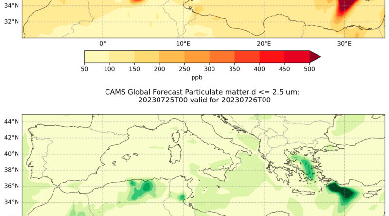
Greece is undergoing its longest heatwave on record, according to senior officials and the forecast shows little ease for the coming days so it is expected a further rise in emissions. The CAMS PM2.5 forecast show continued emissions for the coming days, especially in Rhodes.

The situation is worsening quickly also in the Italian island of Sicily with nearly 50 fires detected in the last days. The signal was weak at the moment of writing this article (26 July) but CAMS global model shows significant carbon emissions expected in the coming days.
The sweltering heat across the Mediterranean and the strong winds also favored the conditions for a series of wildfires in Northern Africa with Algeria and Tunisia most affected. Algeria saw the most dramatic consequences with more than 30 people dead, including 10 firefighters, and some 1,500 evacuated in nearly 100 blazes. Most of the fires were under control on 26 July.
CAMS data show a clear increase in the fire radiative power for the region in July. The Fire Radiative Power data shows clear spikes in both countries on 24 July. Morocco also saw higher than average wildfires but earlier in the month, from mid-July.


Regarding carbon emissions, Tunisia recorded its highest numbers for July on record. To date (Thursday 27 July) Algeria and Morocco show high emissions for the month but not beating previous records. Overall, Northern Africa has seen the third highest carbon wildfire emissions for July on record.
The extremely large wildfire smoke plume from the Algerian wildfires on 24 July was captured by the Copernicus’ Sentinel-3 satellite, that has a lower spatial resolution than Sentinel-2.
The #heatwave in the Mediterranean is causing multiple weather extremes
On 24 July
➡️Air T° in Tunis 🇹🇳 and Palermo 🇮🇹 rose to record values of 49°C and 47°C respectively
➡️Devastating #wildfires 🔥 killed 34 in Algeria 🇩🇿⬇️#Sentinel3 🇪🇺🛰️image of the same day pic.twitter.com/8ogLEHUuKy
— 🇪🇺 DG DEFIS #StrongerTogether (@defis_eu) July 25, 2023
CAMS monitors permanently the largest wildfires around the world with particular attention to the peak of the seasons in the Northern and Southern Hemispheres. The data is available free of charge and for any kind of use in the Atmosphere Data Store.
The service also provides ready-to-use charts with the forecasts of the main pollutants and greenhouse gases for the regional ensemble model and the global model.
Courtesy of Copernicus Atmosphere Monitoring Service’s (CAMS)
Have a tip for CleanTechnica? Want to advertise? Want to suggest a guest for our CleanTech Talk podcast? Contact us here.
Latest CleanTechnica.TV Video

CleanTechnica uses affiliate links. See our policy here.