Wheat in the Pacific Northwest: Understanding the Impacts of Droughts and Heat Waves
Graphics and Data Analysis By: Max Borrmann
Additional Data Support: Joe Kington, Jaap Schellekens, and Tessa Kramer
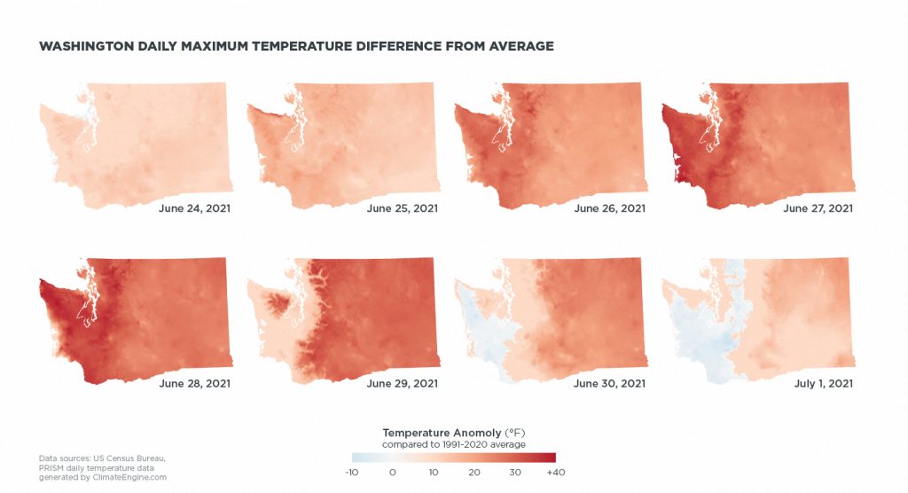
In late June of 2021, the U.S. Pacific Northwest experienced an unprecedented heatwave. Temperatures climbed to 116 degrees fahrenheit in Portland and 108 degrees fahrenheit in Seattle, causing regional devastation to lives and economies. A second, less severe, heatwave hit the region again in late July. By this point, 93% of the Pacific Northwest region had also been impacted by drought conditions, and Seattle and Portland had experienced a month and a half without rainfall. From March to August, Washington state saw just 6.9 inches of rain, compared to an average of 13.03 in previous years according to the National Weather Service.
The combined factors of this continued drought and the unprecedented heat waves sapped the soil moisture of the region, threatening a range of crops, including wheat, berries, and evergreen trees harvested for the Christmas season. Such severe weather events present unpredictable and damaging impacts for the agricultural industry. The combined tools of Planet’s daily satellite data and public data on crop conditions and yields can offer ways for agricultural organizations to map, measure, prepare, and respond to the impacts of temperature anomalies and droughts on certain key crops in their region.
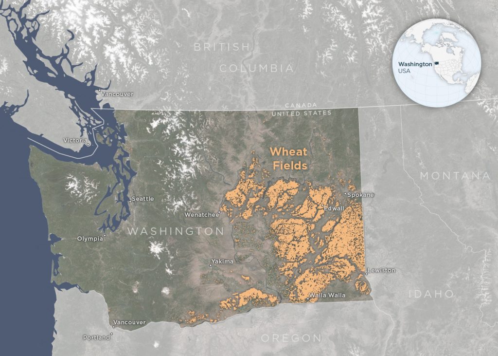
The heatwave in the Pacific Northwest proved particularly damaging to regional wheat crops. In 2020, Washington state was ranked fourth in the United States for the top wheat producing state, and the crop represents about $800 million for the state. However, in early July of 2021, a U.S. Department of Agriculture report rated the condition of 68% of Washington’s spring wheat and 36% of the state’s winter wheat as poor or very poor. By September, the U.S. Department of Agriculture’s annual Small Grains 2021 Summary reported that the total wheat production in Washington fell by nearly 50% to 87.1 million bushels in 2021, from 116 million bushels in 2020. At a closer scale, this change was also reflected in Lincoln County, WA. There 2021 spring wheat yields measured 24 bushels/acre, which represents only 45% of the yields reported in 2020: 53.6 bushels/acre.
For farmers and growers everywhere, the timing for planting and harvesting is critical. Washington’s spring wheat is planted in early spring while its winter wheat is planted in fall. The winter wheat is then harvested in July while the spring wheat harvest starts around the beginning of August. But this year in the Pacific Northwest, spring rains stopped falling just as farmers began planting the spring wheat. Then farmers reported that the heat waves caused a significant amount of the dry land wheat (wheat that only receives water from precipitation) to mature too early, changing the quality of the wheat. Moreover, farmers were again challenged when planting began for winter wheat in fall as the land still lacked crucial moisture, potentially causing negative impacts to next season’s yield. Satellite data can empower farmers and the companies that serve them to precisely monitor and prepare for these changes in a time-sensitive manner, but it can also illuminate crop conditions in real time.
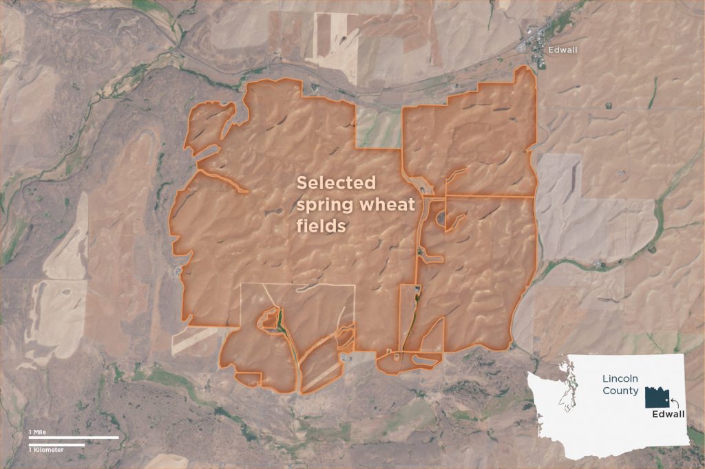
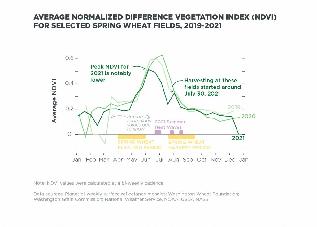
Using Planet’s surface reflectance datasets, farmers and growers can measure the amount of healthy vegetation in their fields using the Normalized Difference Vegetation Index (NDVI), which provides an estimate of crop health. This is data acquired from Planet’s satellite images that can be analyzed over time and compared year to year and season to season. In the below graphic, Planet’s data reveals a noticeable decrease in healthy biomass in 2021 for a group of fields near Edwall, Washington, located in Lincoln County. A steep dip in NDVI follows the first unprecedented heat wave, possibly revealing the compounding impacts of both the drought and heat wave.
Planet’s recent acquisition of VanderSat, a leading provider of advanced earth data and analytics focused in agriculture and water analytics, will enable even more research and monitoring programs for agricultural production impacted by drought and weather anomalies. VanderSat’s algorithms provide daily data from around the globe on soil moisture, land surface temperature, and biomass. By using satellite microwave measurements, VanderSat is able to provide daily coverage of soil moisture data without the hindrance of cloud cover. Paired with Planet’s high-cadence and high-resolution satellite imaging capabilities, VanderSat’s data can be leveraged by farmers and the companies to mitigate risk, manage crops, and plan their growing seasons with increased accuracy.
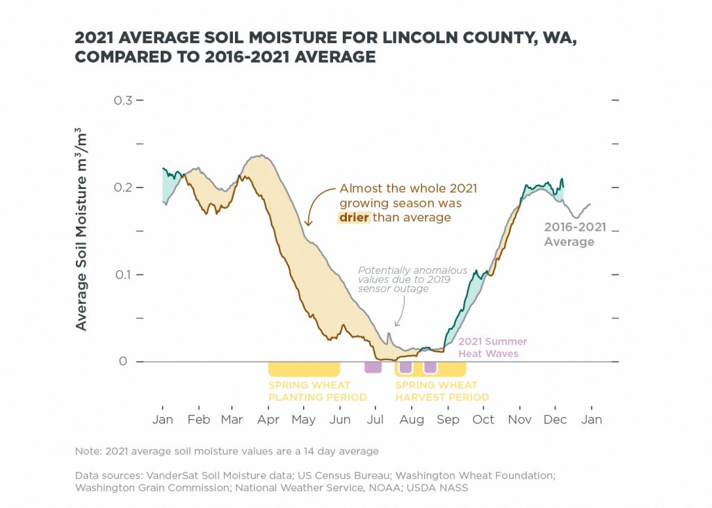
The above graphic highlights how the soil moisture in Lincoln County, Washington was consistently drier than average for almost the whole 2021 spring wheat growing season. VanderSat’s soil moisture in this analysis is at 5cm depth, and represents moisture that is replenished by precipitation, or in other cases irrigation. This type of data can reveal early insights for growers looking to begin their planting, and working to generate expected timelines for harvest. With VanderSat’s average soil moisture data, Planet’s agricultural customers can now analyze time-series data allowing them to retrospectively analyze the impacts of drought and temperature anomalies on their crops. With that knowledge, they can make more informed decisions around planting, irrigation, and harvesting.
This summer, the Pacific Northwest agricultural industry experienced the unprecedented impacts of these two combined environmental stressors. Researchers estimated that a heat wave of this magnitude would have been virtually impossible without human-induced climate change, and with continued warming, these extreme events could become more frequent. Moving forward, as farmers, companies, and world leaders look to mitigate and prevent the worst impacts of global droughts on food systems, they can turn to Planet’s daily satellite insights for informed agricultural decision making, keeping their practices resilient and adaptable.


)