Air quality expert EarthSense has announced a new release of its MappAir® high-resolution map of air pollution, with powerful new features and improved scalability from global down to 10 metres or street level.
MappAir® now provides hourly concentrations of five pollutants, adding ozone (O3,), sulphur dioxide (SO2) and particle matter (PM10) to its existing nitrogen dioxide (NO2) and particle matter (PM2.5) measures. Another new feature of MappAir® is that its data is now accessible via a simple application programming interface (API) which enables multiple options for users to access the data.
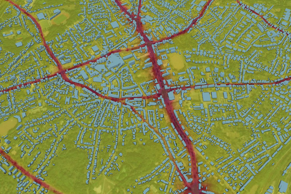
MappAir® City real-time model of NO2 in the region of Essen, Germany.
EarthSense incorporates a range of reliable data sources into MappAir®, including data from satellites, weather data, traffic counts, static sources and its own Zephyr® air quality monitors. MappAir® is the only air pollution model that uses a complex modelling technique called computational fluid dynamics (CFD), which examines the flow and dispersion of air in built-up environments enabling improved pollution measures in urban canyons – areas where a street is flanked by buildings on both sides.
EarthSense Head of Modelling, Dr. Antoine Jeanjean commented: “Using CFD allows EarthSense to offer highly detailed insights into air pollution on a scale previously not achievable with traditional methods. MappAir® makes air pollution data more accessible than ever, which is important for demonstrating the impact of pollution on human health and the environment.
These latest developments mean we can not only monitor pollution at street level but can now build a global picture of air pollution and incorporate a greater number of pollution sources. Furthermore, MappAir® now offers a three-day pollution forecast for the entire globe,” continued Dr. Jeanjean.
MappAir® can identify when and where pollution levels are at their highest and lowest, making it a highly valuable tool for use in many applications including traffic light sequencing, clean route apps for cyclists and walkers, and defining control zones where hybrid vehicles automatically switch to electric mode on entering the area.
Tripsology, an online resource for travellers, is using MappAir® to produce an index of air pollution levels at its featured destinations around the world. Travellers can check pollution levels before deciding on a destination.
Shropshire County Council is also using MappAir® within its air quality webpage designed by EarthSense, which members of the public can use to check pollution levels in their area.
EarthSense Managing Director, Tom Hall said: “We are focused on continuous product development to suit the needs of users. The advances to MappAir® enables organisations around the world to benefit from accessing the best available data on this scale and resolution.”
MappAir® is validated against air quality data from the Department for Environment, Food and Rural Affairs (DEFRA), diffusion tubes, and a rapidly expanding network of EarthSense Zephyr® air quality sensors in mobile and static configurations ensuring a high level of accuracy.